Cameroon A-Level GCE 2021 Geography paper 3 past questions. You can find all Geography 3 June 2021 exam past questions from this page.
As you prepare for the upcoming GCE Advanced Level exams, past questions will be of great help as via the studying of past exam papers, you will easily get an idea f the exam setting.
Also, past questions can be used to test oneself by putting yourself in exam condition. This should help you learn how to program your time to fit real exam conditions and overcome stress during the examination.
GCE Advanced Level Geography 3 – June 2021
INSTRUCTIONS:
Answer FOUR QUESTIONS in all.
Answer question ONE and three others, choosing ONE question from SECTION B and TWO from SECTION C.
QUESTION ONE carries thirty-one marks and the rest carry twenty-three marks each.
Only the required number of questions will be marked.
In answering questions on this paper, you are encouraged to refer to your own field and practice work where relevant. Credit will be awarded for such references.
Candidates are advised NOT to attempt the questions on field investigation if such an exercise has not been carried out.
Marks will be awarded for well-annotated maps and diagrams where these are relevant.
You are reminded of the necessity for good English and orderly presentation in your answers.
Calculators are allowed.
Materials required: Topographic maps, Graph Paper and two outline maps of Cameroon.
A-Level GCE 2021 Geography paper 3 past questions
SECTION A (COMPULSORY)
MAP WORK
1. Study the topographic map extract of Mabombe at 1:50.000 provided and answer the following questions.
a (i) Draw a sketch of the network of the stream that meets the RiverDibombe south of 4°40′ at spot height 111 and rank the stream using Strahler’s method. (6 marks)
(ii) Establish a frequency table of the stream order from the sketch drawn above. (3 marks)
(iii) Calculatethe average Bifurcation Ratio for the stream pattern and interpret your result. (5 marks).
b. Briefly describe the distribution of vegetation on the whole map area. (4 marks)
c. Identify the patterns and describe the istribution of settlements on the whole map area. (5 marks)
d. (i) Account for the location of the plantation in the north western section of the map. (4 marks)
(ii) Using evidence from the map, state THREE other economic activities performed in the areaother than plantation farming. (6 marks)
SECTION B
FIELD WORK AND TECHNIQUES
2. You have carried out and investigative fieldwork in one of the following topics
- River characteristics
- Weather observations
- Vegetation characteristics
- Functional segregation
- Shopping harbits
- Modern factory or cottage -local) industry.
Choose one of the topics and answer the following questions:
a) Using a sketch map, locate the area of your field investigation. (4 marks)
b) State your objective and the hypothesis that guided your investigation of the topic. (2 marks)
c) What tools did you use? (3 marks)
d) Describe how your data was collected (5 marks)
e) How was the data analysed and presented? (6 marks)
f) What were your findings and conclusion? (3 marks)
eography paper 3 past questions – SECTION B Continues
3. Study the table below showing the slope angle and soil depth on a farm in Wotut village (Buea).
| Sites | Slope angle (cm) | Soil depth (cm) | Rank Slope | Rank Soil depth | Differences (d) | Differences Squared (d2) |
| 1 | 6 | 58 | 8 | – | 5 | 25 |
| 2 | 12 | 40 | 7 | 4 | 3 | 9 |
| 3 | 13 | 20 | – | – | -3 | – |
| 4 | 14 | 18 | 5 | 10 | – | 25 |
| 5 | 5 | 60 | 9 | – | 7.5 | 56.25 |
| 6 | 23 | 25 | – | 7.5 | -5.5 | – |
| 7 | 19 | 30 | 4 | 5 | – | 1 |
| 8 | 27 | 25 | 1 | 7.5 | -6.5 | 42.25 |
| 9 | 20 | 29 | – | 6 | – | – |
| 10 | 3 | 60 | 10 | – | 8.5 | 72.25 |
| ∑d2 = |
a) (i) Complete the table above by inserting the missing figures.
(ii) State the null hypothesis(Ho) tested on the table above.
b) (i) Calculate the correlation between slope angle and soil depth using the Spearman’s Rank Correlation Coefficient (rs) formula stated as:

where rs, the Spearman’s correlation coefficient, d2 is the sqyare difference in rank, and n is the number of sites.
Study the levels of significance below
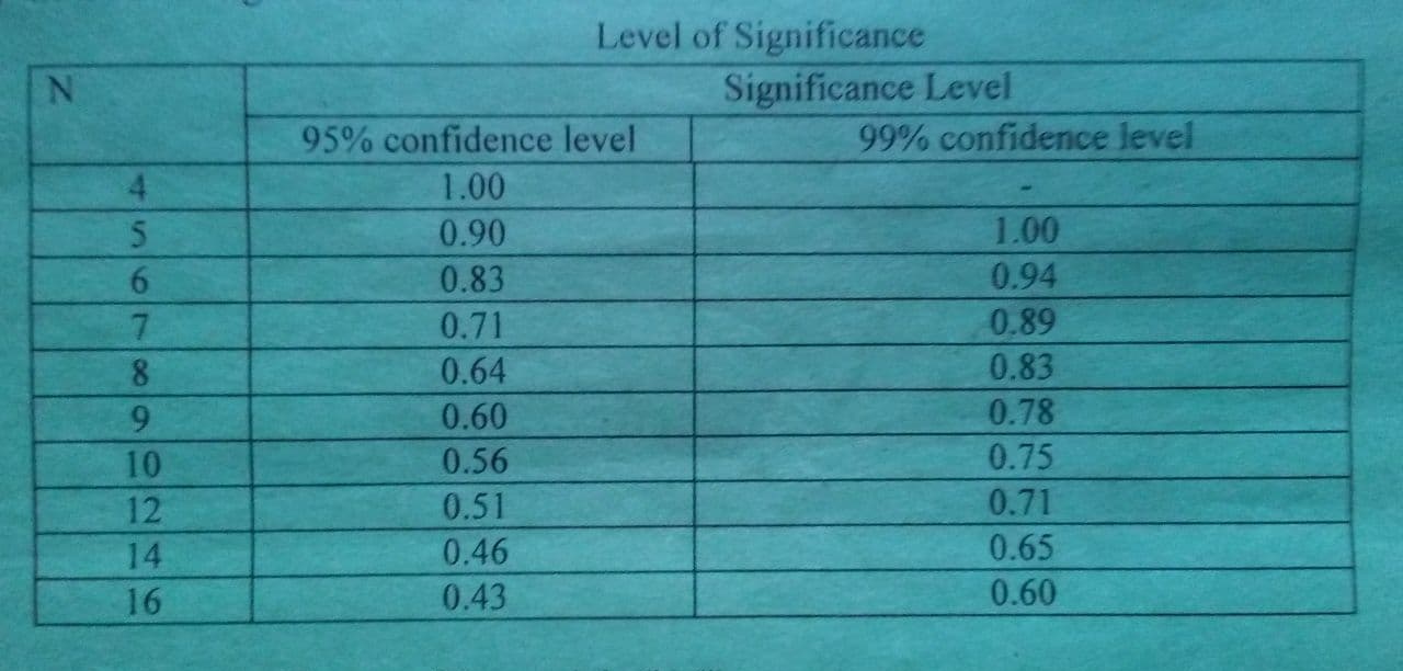

(ii) State the statistical significance of the result in (b) (i).
c) (i) Describe and account for the relationship between slope angle and soil depth as portrayed on the table above
(ii) State at least two importance of the Spearman’s Rank Correlation Coefficient.
SECTION C
4. a) Explain how the movement of air masses causes the seasons in Cameroon.
b) (i) Briefly describe the spartial distribution and characteristics of plantation farming system in Cameroon.
(ii) Describe any TWO strategies used by government to tacle physical problems faced by peasant farmers in the Northern Lowlands.
5. a) Using the otline map of Cameroon provided, loate and briefly describe the main vegetation types in Cameroon.
b) i) Identify major industries and their sources of raw materials in the Western Industrial Triangle.
ii) What efforts have been put in palce to boost the industrial sector of Cameroon?
6. a) Consider the Coastal Lowlands of Cameroon and briefly describe its relief and drainage characteristics
b) Explain the consequences of rural-urban migrations in Cameroon on the rural areas and communities.
c) Discuss at least three measures which have been udertaken to inimise such movements.
7. a) Examine the distribution of water resources in Cameroon.
b) (i) Locate and describe the spatial pattern of rail way transport network in Cameroon
(ii) Account for its present declining state.
Comment(s):
Related posts: